The EGNOS Data Access Service (EDAS) offers ground-based access to EGNOS data through the Internet on a controlled access basis. EDAS is the single point of access for the data collected and generated by the EGNOS ground infrastructure - mainly Ranging and Integrity Monitoring Stations (RIMS) and Navigation Land Earth Stations (NLES) - distributed over Europe and North Africa.
Geared towards users requiring enhanced performance for professional use, EDAS provides these with the same data that is broadcast by the EGNOS satellites (EGNOS Message) in near real-time. EDAS allows users to plug into EGNOS ground infrastructure to receive the data collected, generated and delivered by the EGNOS system. In this way, EDAS delivers EGNOS data to users who cannot always view the EGNOS satellites (such as those in urban canyons) or to support a variety of other value added services, applications and research programmes.
EDAS primarily provides the following types of data:
- Raw GPS, GLONASS and EGNOS geostationary satellite observations and navigation data collected by the entire network of RIMS and NLES;
- EGNOS augmentation messages, as normally received by users via the EGNOS geostationary satellites.
The details and conditions of EDAS are described at EDAS Service Definition Document.
EDAS Services
The main services provided by EDAS are:
Main Data Stream Services
The raw observation data gathered by EGNOS stations, including RIMS sites and NLES stations, is provided by EDAS in real-time with an update rate of one second. The main types of data provided are:
- Service Level 0 (SL0): provides data encoded in ASN.1 format - recommended for those users willing to transmit data in raw format or in a format that allows complete reconstruction after decoding.
- Service Level 2 (SL2): this is used to transmit data in the RTCM 3.1 standard.
EDAS Client Software - a platform-independent interface - allows users to connect to these Service Levels and retrieve data. This application is available to users after registration and is described in the EDAS Client SW Manual (available to registered users for download in the EDAS download section).
EDAS Data Filtering Service
The EDAS Data Filtering Service allows EDAS users to access a subset of the Service Level 0 or Service Level 2 data. The upgraded 2.0 version of the EDAS Client SW makes it possible to select one of the available predefined groups, which are a subset of the EGNOS stations, and the data rate of the received messages.
This means that EDAS users can subscribe to a predefined group of RIMS and retrieve data from these sets of stations at 1Hz or 1/30 Hz, thereby reducing the bandwidth consumption and amount of data to be processed on the user side. The list of available groups and information on how to access this EDAS Service can be found in the EDAS Client SW User Manual, which is available to registered users for download in the EDAS download section.
EDAS SISNeT Service
The EDAS SISNeT service provides access to messages from EGNOS GEO satellites transmitted through the Internet using the SISNeT protocol, a full description of which is available in the SISNeT User Interface Document. Specific guidelines on how to access and use the EDAS SISNeT service are available in the EDAS SISNeT User Information Package which is available to registered users for download in the EDAS download section.
EDAS FTP Service
The EDAS FTP Service allows EDAS users to get EDAS/EGNOS historical data in various formats and at various data rates. EDAS users may access this service using a standard FTP client. Specific guidelines on how to access and use the EDAS FTP service, including information on naming conventions and the folder structure, are available to registered users in the EDAS FTP-User Information Package, which you can find in the EDAS download section.
NTRIP Service
The EDAS-based NTRIP service retrieves GPS and GLONASS raw measurements from the EGNOS stations (RIMS and NLES) and disseminates this information through the NTRIP (version 2.0) protocol in RTCM 3.1, RTCM 2.1 and RTCM 2.3 formats. Differential GNSS corrections and phase measurements, as well as additional messages for RTK (real-time kinematic) implementation, are provided within the NTRIP data.
NTRIP is an RTCM standard designed for disseminating differential correction data (e.g. in the RTCM-104 format) or other kinds of GNSS streaming data to stationary or mobile users over the Internet, allowing simultaneous PC, laptop, PDA, or receiver connections to a broadcasting host. NTRIP supports wireless Internet access through Mobile IP Networks like GSM, GPRS, EDGE, or UMTS.
Detailed information on how to connect to and use the EDAS NTRIP service can be found in the EDAS NTRIP-User Information Package, which is available to registered users for download in the EDAS download section.
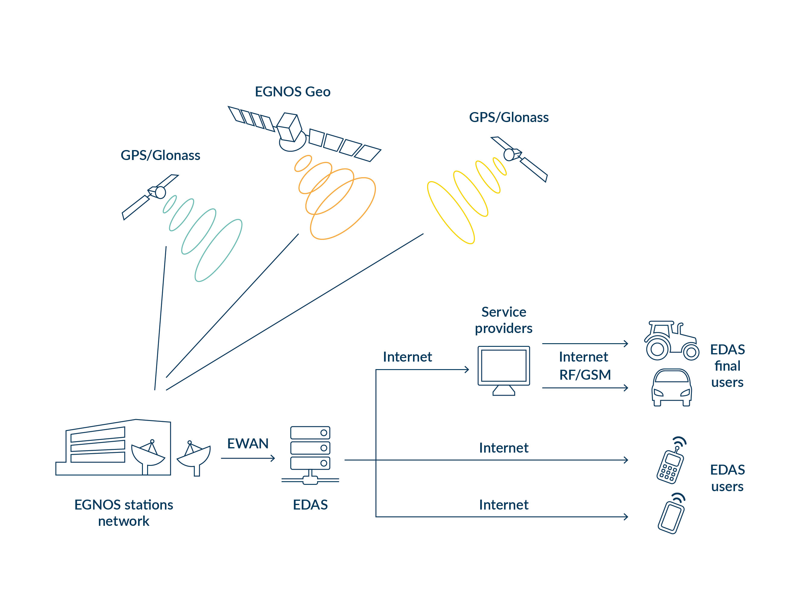
EDAS high-level architecture
Raw observations from EGNOS network
| For each RIMS (and NLES) and each visible GPS satellite | For each RIMS (not NLES) and each visible GLONASS satellite | For each RIMS (not NLES) and each visible EGNOS GEO | ||||
|---|---|---|---|---|---|---|
| GPS navigation data | GPS L1 code measurements | GPS L2 code measurements | GLONASS navigation data | GLONASS L1 code measurements | GEO navigation data | GEO L1 code measurements |
| GPS receiver channel status | GPS L1 phase measurements (accumulated Doppler from satellite acquisition) | GPS L2 phase measurements (accumulated Doppler) | GLONASS receiver channel status | GLONASS L1 phase measurements (accumulated Doppler) | GEO receiver channel status | GEO L1 phase measurements (accumulated Doppler) |
| GPS L1 signal C/N0 ratio | GPS L2 signal C/N0 ratio | GLONASS L1 signal C/N0 ratio | GEO L1 signal C/N0 ratio | |||
| GPS L1 code carrier phase coherency indicator | GPS L2 code carrier phase coherency indicator | GLONASS L1 code carrier phase coherency indicator | GEO L1 code carrier phase coherency indicator | |||
| GPS L1 signal status | GPS L2 signal status | GLONASS L1 signal status | GEO L1 signal status | |||
| GPS L1 signal quality | GPS L2 signal quality | GLONASS L1 signal quality | GEO L1 signal quality | |||
EGNOS augmentation message
The EGNOS augmentation message is uplinked and broadcast from the EGNOS geostationary satellites. The augmentation message from EGNOS has been internationally standardised with other Space-Based Augmentation Systems (SBAS). Its content and format are precisely defined in the public document: Minimum Operational Performance Standards for Global Positioning System/Wide Area Augmentation System Airborne Equipment.
EDAS data sheet
The following table summarises the types of data that can be retrieved via the different EDAS services. For further information on formats and protocols, users can consult the EGNOS Data Access Service SDD.
| Mode | EDAS Service | Type of Data | |||
|---|---|---|---|---|---|
| Obs. &nav. | EGNOS messages | RTK messages | DGNSS corrections | ||
| Real Time | SL0 & SL2 | X | X | ||
| DF0 & DF2 | X | X | |||
| SISNET | X | ||||
| Ntrip | X | X | X | ||
| Archive | FTP | X | X | ||
Registration
Data is provided to EDAS users upon registration. Once registered, users can plug into EGNOS and receive all its collected and generated data. To get access to EDAS please follow the instructions in the EDAS registration section. If you have any questions or require more information, you can contact our helpdesk at helpdesk@edas-maritime.gsc-europa.eu or call +34 911 236 555.
Usage information
Details and conditions regarding EDAS usage are described in the EDAS Service Definition Document.